Pacific Atlantis - 与那国の海底遺跡
Please refer back to past entries for the full story.
PART 1 Across the Sea to Yonaguni - 与那国まで海を渡って
PART 2 This is Yonaguni - これは与那国
Ever since being told nearly four years ago by Mark White, an Australian writer and educator, that there were “underwater ruins” in Yonaguni, we knew that we would have see them for ourselves one day. Looking on the Internet reveals some hazy photos and a lot of Velikovskian theories. Not one clearly written account of what is actually there seems to exist, leaving the whole thing perfectly poised in the gap between proper scientific description and utter science fiction fantasy akin to UFO’s or ESP. Not that these fields are not worthy of scientific research, in fact it begs the question, why is proper science so loath to extend in this direction? It didn’t seem likely we would find the answer to that, so we set out at least to attempt to clarify whether these ‘ruins’ are natural or man-made. Even that much seemed impossible to determine from what could be gleaned off the Net.
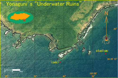
The vicinity of Yonaguni's Cape Arakawa, showing the locations of the main site ('iseki', or ruins in Japanese), and the 'stadium'.
私達は与那国の海底遺跡についての好奇心があるのは、およそ四年前マーク・ホワイトと言うオーストラリア出身の作家と教育家にそう言う物があるのが教えられたからです。その時絶対ある日見に行くと決めました。インターネットに調べると、不鮮明な写真や信じられないスペキュレーションしかは出て来ない。なぜそこに触れる物があるのに、ユーフォや超能力のように非科学的な説明が無さそうですか。今回この問題の解決を見つけるはずはなかったんですけど、少なくともこの「遺跡」は自然的なもの、それとも人工的なものだろうと、自分で調べたかったのです。ネットでの情報を見ると、そこまでもはっきり決める事が出来ない状態です。
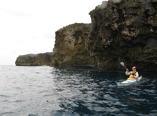
Paddling the south coast of Yonaguni shortly after seeing the ferry depart and leave us stranded on the island for several days. We enjoyed relatively calm if rainy conditions as the weather chose to attack the opposite coast that day.
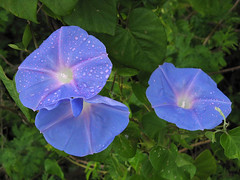
The ferry overtook us while we paddled around Japan’s westernmost cape and turned the corner along the south coast of Yonaguni that early morning of our second full day on the island. We were thus committed to stay until the next ferry run four days later. It was a windy, rainy morning with low dark clouds racing across the sky, but we felt good about our decision to stay as we paddled along the cliffy limestone coast. After a while we eased through a channel in the reef into the coral lagoon near Higawa, one of very few seaside villages in Japan with no artificial port, just a shallow lagoon surrounded by a nice sand beach. Surprised at this, we pulled up on shore and had a walk around the village in the falling rain. Morning glories grew as weeds in every neglected piece of land, their large purple-blue flowers opened fully against the raindrops. Among the village’s concrete houses a somewhat dilapidated wooden one caught our attention. Such traditional structures have no walls except the wooden shutters that are slid in in case of a typhoon, so even now the house was fully open to the outside. We contemplated for a moment the aesthetic beauty such traditional dwellings possess, of there being no ‘inside’ and ‘outside’, of being able to sit on the tatami mat watching and listening to the falling rain. Little did we know that we would be living here for the rest of our stay on the island.
The imposing snout-like cliff at Cape Arakawa. An outlying rocky shoal creates a nice protected inlet on the otherwise exposed coast for anchoring the kayaks. The inlet's rich sealife also makes for easy, wonderful snorkeling. The iseki site lies in the ocean just beyond the shoal.
日本の最西端を回って、与那国の南海岸を通りながら、フェリー追い越されました。さて、次の便まであと四日間滞在するに決まっているでしょう。風の強い、にわか雨、低くて黒い雲が空を飛ぶ日だったのに、なんとなく気持ちよかった。石灰岩の絶壁のある海岸をしばらく辿るとそれが終わり、リーフの狭い入り口に入って、比川と言う集落の日本で非常に珍しい自然の港に入った。ここで上陸して、雨でぬれた集落を歩いていた。雨の雫が乗っていた朝顔の青い花は、あちこちの蓬生で咲いました。集落のコンクリートの家の間、突然一軒の古い伝統的な木造の家に気が着きました。壁のない畳部屋は、目の前に広がっていた。これは、日本の古い家の最高の雰囲気。外と中は分けてない。畳に座って、周りの雨を見て、その響きを聞くのは、素晴らしい事でしょう。その時私達はまだ知らなかったのに、この家で今日から泊まる事に成るでしょう。
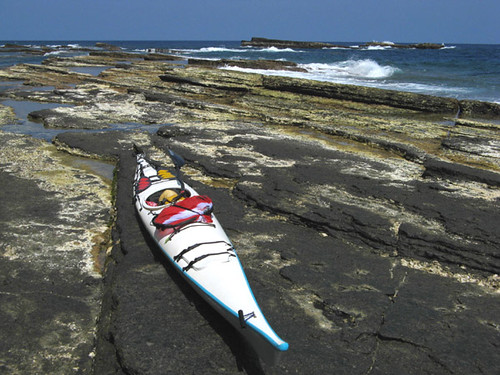
At low tide, landing on the shoal near the iseki site is easy, but at such time the currents tend to be so strong that only a quick 'flyby' of the ruins is possible. Care is required as the tide rises, since waves begin crashing over the low serrated rocks with little warning. The outlying rocks in the background lie about half-way on a line connecting here to the 'stadium' site.
Back on the sea again, we hurried toward the imposing 50-meter overhanging cliffs of Cape Arakawa, where the mysterious ruins are located. Donning goggles, we began purposely capsizing and scanning the seabed for anything suspicious. The superb transparency of the seawater made the search easy. All around the cape, the bedrock consisted of rather unusually flat sections with long straight cracks running through them – unusual but hardly artificial-looking. But suddenly in one place, the cracks seemed to converge onto a small area of incredibly straight-edged, rectangular looking blocks. We had found the mysterious ruins at last!
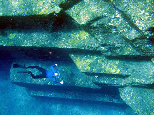
Leanne dives in the crystal clear waters, lending depth and scale to the iseki 'ruins'.
又海に出て、東にそびえている荒川崎に50メートルの懸崖を目指します。ここは、うわさの海底遺跡があります。シュノーケルのゴッグルを掛けて、技と転覆しながら、遺跡をさがします。海の妙な透明度のお陰で、探すのは早くて簡単ででした。岬の辺り、岩床は普段より大きな平板を成し、多くの真っ直ぐの割れ目が有った。ちょっと不思議だけど、人工までと言えない。でも突然、一箇所だけで、この割れ目が集中して、直角のブロック見たいの集まりが有った。海底遺跡発見!
Although lacking geometric regularity, the dead-straight edges of rock all but convince one of the site's human origins.
We parked the kayaks under the overhangs of the cape in a small inlet perfectly suited for the purpose, tying them to an underwater boulder, put on our snorkel gear and swam out to investigate at close range. The ruins are in about 7-15 meters of water, and the unusual-looking area is relatively small, maybe 40x15m or so. Because the shapes seem hewn out of the living bedrock, it hardly looks like the remains of a building or any other structure. But the edges and shapes seem so regular that one can’t help thinking they must be man-made. Adding to this conviction is the uniqueness of the location: if natural, then one would expect to find such formations in more than just this one place. To us, the most likely explanation is that this was an ancient quarry. The people that used this place, lacking sophisticated stone-cutting tools, may have taken advantage of the natural straightness of the fractures in the bedrock, perhaps hammering wooden wedges in to cleave more or less regular blocks from the slab. What they did with these or where they took them is anyone’s guess.
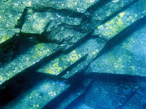
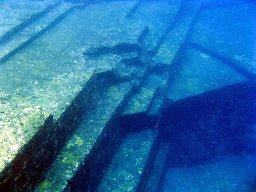
Looking down from the surface, straight lines from several angles seem to converge on the 'center' of the site where an irregular rough spot further mystifies the observer.
岬の天辺の真下にあった便利な入り江でカヤックを底にあった大石に結んで、シュノーケル装備を着けて遺跡まで泳ぎ出した。現場は、水深の7-15メートルくらいで、サイズは比較的に小さくて、およその長さ40メートル、幅15メートルです。岩の不思議な形は、直接岩床から切られた見たいですから、この遺跡はビルなどであったの気が余りしません。しかし、この端は完全に直線で並列し、面の部分も完全に平面的で、本当に人工的に見られます。それと、ナチュラルな物だったら、こんな物が付近の数箇所にあるはずじゃないんでしょう。でも、ここだけの小さな一箇所しかありません。色々考えて、是は古代の石切り場じゃないんでしょうか。もうしかして寛淳は道具しかなかったから、古代の人々はこの辺の岩の直線の割れ目を有利にして、木の割り楔を入れて、綺麗なブロックを取れました。このブロック自体はどうに成ったのは勿論、誰も知りません。
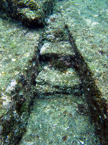
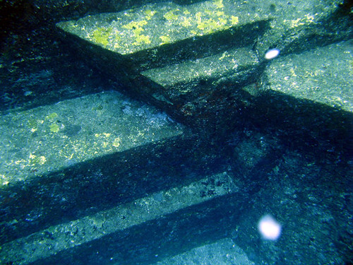
Nearby, what looks like steps hewn into a V-shaped notch connect one level of the slab with another.
We could find no marks along the edges of any of the rocks that would clearly indicate human interference, however such marks would not be left by wooden tools and in any case the rock has weathered and became covered with sea life over the ages, erasing any minor marks. Of course, one can conjecture that 10,000 years ago or more, when the quarrying (if that’s what it was) likely took place, the sea level was lower because of the ice age or tectonic movements of the earth’s crust, so that this place could have been just on the shoreline. The vertical drop just next to it would have provided an excellent natural berth for a ship onto which the blocks could have been loaded immediately after being cleaved off.
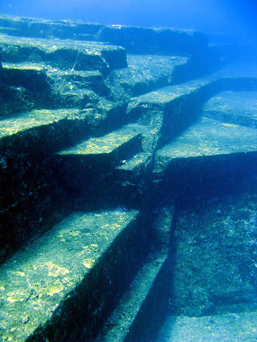
In this oblique picture taken from the surface, one can see nearly the entire extent of the artificial-looking part of the bedrock.
岩の端を近く見ても、はっきりの人工のしるしを一つも見つける事が出来なかった。しかし、木で作った道具は、大きな傷を残すはずはないでしょう。そして、侵食や海の生き物の影響で、小さな傷などはもう完全に見えなくなりました。勿論一万年以上前、いわゆるこの場所の活動の時代、海のレベルは氷期や地殻変動の為に今日より低くかったかもしれません。多分、この場所は丁度海岸にあって、隣のドン深い所は便利な埠頭になった。取ったブロックを直接船に積む可能性があったかもしれません。
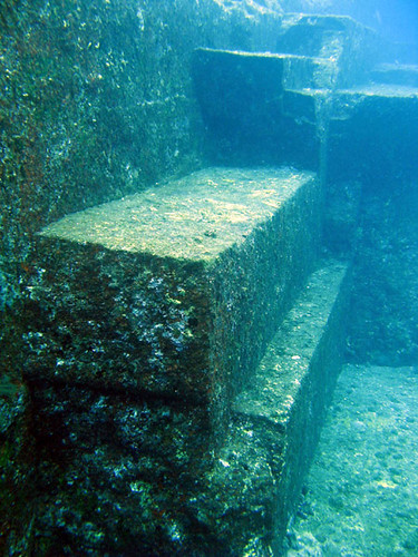
A closeup of the blocky nature of the rock. Although curves and irregularities exist where the rock seems to have fractured 'against the grain', most surfaces and edges are straight and true. Common sense can't discount primitive peoples having quarried blocks of good quality rock from here.
We were truly surprised and puzzled by this place. We expected to find an unusual but nevertheless natural formation, yet it does not seem to be so. So who were the people that changed the shape of this rock slab, and what were they doing? No one knows, but one does not need to manufacture tales a la Atlantis to make this place interesting. Anyone who visits can feel the deep and profound mystery that resides here fully for themselves.
この場所はミステリーの気持ちが出ました。期待したのは、不思議なのに人工のものじゃない岩層でした。しかし見るとやっぱり、人工の物でしょうと考えるようになった。でも、この岩を切った人々、一体誰だったでしょう。そして何の為。それは今誰も知らない。だけど、これについてアトランチスっぽい物語を作らなくていいと思います。ここを訪れる人は、深いミステリーの力を自分で感じる事が出来ます。
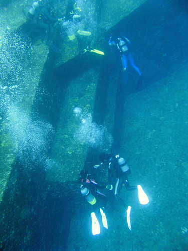
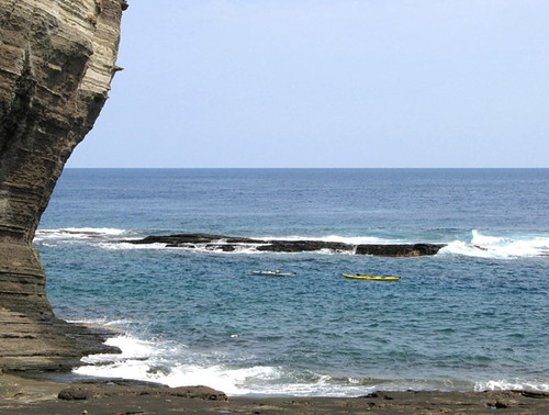
Divers visiting the site (photo taken from overturned kayak). Yonaguni is one of the most fabled diving spots in Japan, due in large part to the existence of this place. Tour boats disgorge divers and snorkelers, allowing them to drift on the current before picking them up no more than 30 minutes later. If that doesn't turn your crank enough, in winter you can dive with a huge school of 3-meter hammerhead sharks off Cape Iri. We could not find data on how many divers have been eaten to date.
There is another place of some interest nearby called ‘the Stadium’ and after asking the captain of one of the diving boats bobbing nearby for directions, we were able to locate it in about 30 meters of water, and rather farther away from shore than the quarry. As a testament to the amazing clarity of the Yonaguni seas, the whole thing was visible clearly even from the surface. With Leanne holding the position of the kayaks against the current, I took some deep breaths and dove the whole way down to the bottom to investigate. Surprisingly, the flat floor of the ‘stadium’ turned out to be not sand but a gently sloping, enormously large, completely flat slab of rock. The curved, exfloliated plates around it form the ‘bleachers’ of the stadium. As interesting as this formation may be, though, to me it does not seem artificial. I wonder if any geologist out there could elucidate on out how such a thing might form.
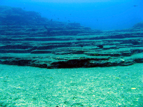
The 'stadium' site stretched my snorkeling limits with its depth of nearly 30 meters. An enormous, monolithic, gently sloping rock slab forms its floor, and it is surrounded by stepped rock formations loosely reminiscent of bleachers.
海底遺跡の近くにある別のある程度興味深い「スタジアム」と言うポイントもあります。潜りのお客さんが乗った船の船長に聞いて、位置を教えてもらいました。水深の30メートルなのに、海の透明度のお陰で、水面からもはっきりみえました。海岸線から少し離れた、海流の良く感じる場所だったので、カヤックをトーラインで結んだ後、里杏がボートの位置を安定して、私は深呼吸をして、下まで潜りました。びっくり程の事は、スタジアムの中心にある大きい平らの所は、砂じゃなくて、巨大で完全に平板な岩だった。周りの丸い観覧席みたいものは、剥落した岩板と見られます。しかし、このフォーメーションは不思議なのに、中々人工の感じはしません。読者の地質の専門家がいれば、この生成に着いてのコメントをどうぞ。
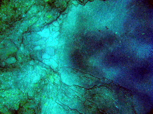
An overhead picture of the stadium, taken from the surface. Though the image has been manipulated a bit to enhance contrast, it is nevertheless a testament to the clarity of the water - the rocks are 20-30 meters down! It's interesting that like the iseki site, there seems to be a point on which many lines converge. The entire right side of the picture is part of a gigantic rock slab. To get an idea of the scale, the area pictured is maybe 25 meters across.
PART 1 Across the Sea to Yonaguni - 与那国まで海を渡って
PART 2 This is Yonaguni - これは与那国
Ever since being told nearly four years ago by Mark White, an Australian writer and educator, that there were “underwater ruins” in Yonaguni, we knew that we would have see them for ourselves one day. Looking on the Internet reveals some hazy photos and a lot of Velikovskian theories. Not one clearly written account of what is actually there seems to exist, leaving the whole thing perfectly poised in the gap between proper scientific description and utter science fiction fantasy akin to UFO’s or ESP. Not that these fields are not worthy of scientific research, in fact it begs the question, why is proper science so loath to extend in this direction? It didn’t seem likely we would find the answer to that, so we set out at least to attempt to clarify whether these ‘ruins’ are natural or man-made. Even that much seemed impossible to determine from what could be gleaned off the Net.
The vicinity of Yonaguni's Cape Arakawa, showing the locations of the main site ('iseki', or ruins in Japanese), and the 'stadium'.
私達は与那国の海底遺跡についての好奇心があるのは、およそ四年前マーク・ホワイトと言うオーストラリア出身の作家と教育家にそう言う物があるのが教えられたからです。その時絶対ある日見に行くと決めました。インターネットに調べると、不鮮明な写真や信じられないスペキュレーションしかは出て来ない。なぜそこに触れる物があるのに、ユーフォや超能力のように非科学的な説明が無さそうですか。今回この問題の解決を見つけるはずはなかったんですけど、少なくともこの「遺跡」は自然的なもの、それとも人工的なものだろうと、自分で調べたかったのです。ネットでの情報を見ると、そこまでもはっきり決める事が出来ない状態です。
Paddling the south coast of Yonaguni shortly after seeing the ferry depart and leave us stranded on the island for several days. We enjoyed relatively calm if rainy conditions as the weather chose to attack the opposite coast that day.
The ferry overtook us while we paddled around Japan’s westernmost cape and turned the corner along the south coast of Yonaguni that early morning of our second full day on the island. We were thus committed to stay until the next ferry run four days later. It was a windy, rainy morning with low dark clouds racing across the sky, but we felt good about our decision to stay as we paddled along the cliffy limestone coast. After a while we eased through a channel in the reef into the coral lagoon near Higawa, one of very few seaside villages in Japan with no artificial port, just a shallow lagoon surrounded by a nice sand beach. Surprised at this, we pulled up on shore and had a walk around the village in the falling rain. Morning glories grew as weeds in every neglected piece of land, their large purple-blue flowers opened fully against the raindrops. Among the village’s concrete houses a somewhat dilapidated wooden one caught our attention. Such traditional structures have no walls except the wooden shutters that are slid in in case of a typhoon, so even now the house was fully open to the outside. We contemplated for a moment the aesthetic beauty such traditional dwellings possess, of there being no ‘inside’ and ‘outside’, of being able to sit on the tatami mat watching and listening to the falling rain. Little did we know that we would be living here for the rest of our stay on the island.
The imposing snout-like cliff at Cape Arakawa. An outlying rocky shoal creates a nice protected inlet on the otherwise exposed coast for anchoring the kayaks. The inlet's rich sealife also makes for easy, wonderful snorkeling. The iseki site lies in the ocean just beyond the shoal.
日本の最西端を回って、与那国の南海岸を通りながら、フェリー追い越されました。さて、次の便まであと四日間滞在するに決まっているでしょう。風の強い、にわか雨、低くて黒い雲が空を飛ぶ日だったのに、なんとなく気持ちよかった。石灰岩の絶壁のある海岸をしばらく辿るとそれが終わり、リーフの狭い入り口に入って、比川と言う集落の日本で非常に珍しい自然の港に入った。ここで上陸して、雨でぬれた集落を歩いていた。雨の雫が乗っていた朝顔の青い花は、あちこちの蓬生で咲いました。集落のコンクリートの家の間、突然一軒の古い伝統的な木造の家に気が着きました。壁のない畳部屋は、目の前に広がっていた。これは、日本の古い家の最高の雰囲気。外と中は分けてない。畳に座って、周りの雨を見て、その響きを聞くのは、素晴らしい事でしょう。その時私達はまだ知らなかったのに、この家で今日から泊まる事に成るでしょう。
At low tide, landing on the shoal near the iseki site is easy, but at such time the currents tend to be so strong that only a quick 'flyby' of the ruins is possible. Care is required as the tide rises, since waves begin crashing over the low serrated rocks with little warning. The outlying rocks in the background lie about half-way on a line connecting here to the 'stadium' site.
Back on the sea again, we hurried toward the imposing 50-meter overhanging cliffs of Cape Arakawa, where the mysterious ruins are located. Donning goggles, we began purposely capsizing and scanning the seabed for anything suspicious. The superb transparency of the seawater made the search easy. All around the cape, the bedrock consisted of rather unusually flat sections with long straight cracks running through them – unusual but hardly artificial-looking. But suddenly in one place, the cracks seemed to converge onto a small area of incredibly straight-edged, rectangular looking blocks. We had found the mysterious ruins at last!
Leanne dives in the crystal clear waters, lending depth and scale to the iseki 'ruins'.
又海に出て、東にそびえている荒川崎に50メートルの懸崖を目指します。ここは、うわさの海底遺跡があります。シュノーケルのゴッグルを掛けて、技と転覆しながら、遺跡をさがします。海の妙な透明度のお陰で、探すのは早くて簡単ででした。岬の辺り、岩床は普段より大きな平板を成し、多くの真っ直ぐの割れ目が有った。ちょっと不思議だけど、人工までと言えない。でも突然、一箇所だけで、この割れ目が集中して、直角のブロック見たいの集まりが有った。海底遺跡発見!
Although lacking geometric regularity, the dead-straight edges of rock all but convince one of the site's human origins.
We parked the kayaks under the overhangs of the cape in a small inlet perfectly suited for the purpose, tying them to an underwater boulder, put on our snorkel gear and swam out to investigate at close range. The ruins are in about 7-15 meters of water, and the unusual-looking area is relatively small, maybe 40x15m or so. Because the shapes seem hewn out of the living bedrock, it hardly looks like the remains of a building or any other structure. But the edges and shapes seem so regular that one can’t help thinking they must be man-made. Adding to this conviction is the uniqueness of the location: if natural, then one would expect to find such formations in more than just this one place. To us, the most likely explanation is that this was an ancient quarry. The people that used this place, lacking sophisticated stone-cutting tools, may have taken advantage of the natural straightness of the fractures in the bedrock, perhaps hammering wooden wedges in to cleave more or less regular blocks from the slab. What they did with these or where they took them is anyone’s guess.
Looking down from the surface, straight lines from several angles seem to converge on the 'center' of the site where an irregular rough spot further mystifies the observer.
岬の天辺の真下にあった便利な入り江でカヤックを底にあった大石に結んで、シュノーケル装備を着けて遺跡まで泳ぎ出した。現場は、水深の7-15メートルくらいで、サイズは比較的に小さくて、およその長さ40メートル、幅15メートルです。岩の不思議な形は、直接岩床から切られた見たいですから、この遺跡はビルなどであったの気が余りしません。しかし、この端は完全に直線で並列し、面の部分も完全に平面的で、本当に人工的に見られます。それと、ナチュラルな物だったら、こんな物が付近の数箇所にあるはずじゃないんでしょう。でも、ここだけの小さな一箇所しかありません。色々考えて、是は古代の石切り場じゃないんでしょうか。もうしかして寛淳は道具しかなかったから、古代の人々はこの辺の岩の直線の割れ目を有利にして、木の割り楔を入れて、綺麗なブロックを取れました。このブロック自体はどうに成ったのは勿論、誰も知りません。
Nearby, what looks like steps hewn into a V-shaped notch connect one level of the slab with another.
We could find no marks along the edges of any of the rocks that would clearly indicate human interference, however such marks would not be left by wooden tools and in any case the rock has weathered and became covered with sea life over the ages, erasing any minor marks. Of course, one can conjecture that 10,000 years ago or more, when the quarrying (if that’s what it was) likely took place, the sea level was lower because of the ice age or tectonic movements of the earth’s crust, so that this place could have been just on the shoreline. The vertical drop just next to it would have provided an excellent natural berth for a ship onto which the blocks could have been loaded immediately after being cleaved off.
In this oblique picture taken from the surface, one can see nearly the entire extent of the artificial-looking part of the bedrock.
岩の端を近く見ても、はっきりの人工のしるしを一つも見つける事が出来なかった。しかし、木で作った道具は、大きな傷を残すはずはないでしょう。そして、侵食や海の生き物の影響で、小さな傷などはもう完全に見えなくなりました。勿論一万年以上前、いわゆるこの場所の活動の時代、海のレベルは氷期や地殻変動の為に今日より低くかったかもしれません。多分、この場所は丁度海岸にあって、隣のドン深い所は便利な埠頭になった。取ったブロックを直接船に積む可能性があったかもしれません。
A closeup of the blocky nature of the rock. Although curves and irregularities exist where the rock seems to have fractured 'against the grain', most surfaces and edges are straight and true. Common sense can't discount primitive peoples having quarried blocks of good quality rock from here.
We were truly surprised and puzzled by this place. We expected to find an unusual but nevertheless natural formation, yet it does not seem to be so. So who were the people that changed the shape of this rock slab, and what were they doing? No one knows, but one does not need to manufacture tales a la Atlantis to make this place interesting. Anyone who visits can feel the deep and profound mystery that resides here fully for themselves.
この場所はミステリーの気持ちが出ました。期待したのは、不思議なのに人工のものじゃない岩層でした。しかし見るとやっぱり、人工の物でしょうと考えるようになった。でも、この岩を切った人々、一体誰だったでしょう。そして何の為。それは今誰も知らない。だけど、これについてアトランチスっぽい物語を作らなくていいと思います。ここを訪れる人は、深いミステリーの力を自分で感じる事が出来ます。
Divers visiting the site (photo taken from overturned kayak). Yonaguni is one of the most fabled diving spots in Japan, due in large part to the existence of this place. Tour boats disgorge divers and snorkelers, allowing them to drift on the current before picking them up no more than 30 minutes later. If that doesn't turn your crank enough, in winter you can dive with a huge school of 3-meter hammerhead sharks off Cape Iri. We could not find data on how many divers have been eaten to date.
There is another place of some interest nearby called ‘the Stadium’ and after asking the captain of one of the diving boats bobbing nearby for directions, we were able to locate it in about 30 meters of water, and rather farther away from shore than the quarry. As a testament to the amazing clarity of the Yonaguni seas, the whole thing was visible clearly even from the surface. With Leanne holding the position of the kayaks against the current, I took some deep breaths and dove the whole way down to the bottom to investigate. Surprisingly, the flat floor of the ‘stadium’ turned out to be not sand but a gently sloping, enormously large, completely flat slab of rock. The curved, exfloliated plates around it form the ‘bleachers’ of the stadium. As interesting as this formation may be, though, to me it does not seem artificial. I wonder if any geologist out there could elucidate on out how such a thing might form.
The 'stadium' site stretched my snorkeling limits with its depth of nearly 30 meters. An enormous, monolithic, gently sloping rock slab forms its floor, and it is surrounded by stepped rock formations loosely reminiscent of bleachers.
海底遺跡の近くにある別のある程度興味深い「スタジアム」と言うポイントもあります。潜りのお客さんが乗った船の船長に聞いて、位置を教えてもらいました。水深の30メートルなのに、海の透明度のお陰で、水面からもはっきりみえました。海岸線から少し離れた、海流の良く感じる場所だったので、カヤックをトーラインで結んだ後、里杏がボートの位置を安定して、私は深呼吸をして、下まで潜りました。びっくり程の事は、スタジアムの中心にある大きい平らの所は、砂じゃなくて、巨大で完全に平板な岩だった。周りの丸い観覧席みたいものは、剥落した岩板と見られます。しかし、このフォーメーションは不思議なのに、中々人工の感じはしません。読者の地質の専門家がいれば、この生成に着いてのコメントをどうぞ。
An overhead picture of the stadium, taken from the surface. Though the image has been manipulated a bit to enhance contrast, it is nevertheless a testament to the clarity of the water - the rocks are 20-30 meters down! It's interesting that like the iseki site, there seems to be a point on which many lines converge. The entire right side of the picture is part of a gigantic rock slab. To get an idea of the scale, the area pictured is maybe 25 meters across.
Labels: kayak expedition シーカヤック遠征
posted by Leanne and Rik Brezina at
2:22 pm
![]()


3 Comments:
I would like to read more about the house you ended up staying in. I remember the town of Higawa.
By Andre Rivas, at 2:19 am
COOL! What a neat discovery! Good for you guys!
By Anonymous, at 3:05 am
andre:
look for it in the next Yonaguni installment, coming up soon.
-r
By Leanne and Rik Brezina, at 12:39 pm
Post a Comment
<< Home